• Help Support TNDeer:

What do you see? (topo map)

BHC

Well-Known Member
Joined
Sep 16, 2011
Messages
915
Location
Wayne Co. , Tennessee
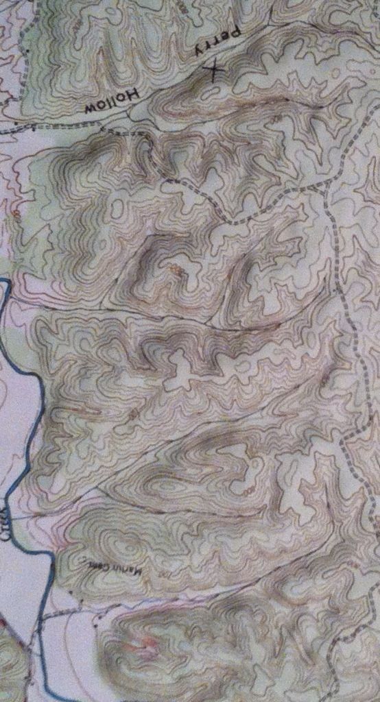
If you had jus aquired this land and were given this map, what do you see at first glance? Mainly as far as stand sights and funnels go? The map is upside down so up is south...
37968381.jpg
 
I like the areas where the main creek cuts up close to the higher terrain - should cause a few choke points where the deer will either have to cross the creek, or have a narrow travel corridor between a steep bluff and the creek. Also anywhere in those gully's I would expect to see a good trail running through any places where you could find a gradual slope.
 
Like Poser, I like the ridgetop fingers. Between Perry Hollow and the logging road, toward the top of your picture, there are several fingers going in different directions, which are not so steep and make for easy traveling for deer - they head up at the top of the ridge. Perfect ambush points.
 
Lots of potential. Those ridge top fingers should be deer highways. Especially for bucks on the prowl! There is a ton of saddles. Hard to beat a deep woods saddle to catch a midday monster.
 
First off, you'll need a four wheeler, cause I promise you there will be deer headed off into those deep hollers.

Second, it looks like where I hunt. So find your South facing hillsides that catch morning sun and hold acorn trees for food. When it turns cold, deer will head there on really cold mornings as this is going to warm quickest.

Watch your thermals and dominant wind directions for intercepting deer headed BACK to bed mid-morning. Also be aware of where your shadow hits the trail (if at all) on sunny mornings so as not to spook turkey (or deer) as they pass.

Remember trails generally look REALLY good on the side of a hill that may not even show at all on flat land.

About an inch above and slightly right of the "M" in Martin? looks like a promising saddle. I'd definitely want to be on that South facing ridge South of that saddle come the colds months.

Just above the n and c looks interesting as well. Especially early and warm.
 
monique06 said:
Rockhound said:
I would say screw the map and start putting in leg work
I agree! adventure is along the way

In my opinion, that's one of the biggest scouting mistakes hunters make. They spend far too much foot-traffic time than is needed.

Take that map, locate as many potential travel route hot-spots as possible, and THEN use footwork to find which of these locations have been used by deer in the past (heavy trails, old rubs, etc.). You can cut down on footwork and intrusive pressure dramatically by having a clear plan of attack before first stepping foot on the property.
 
BSK said:
monique06 said:
Rockhound said:
I would say screw the map and start putting in leg work
I agree! adventure is along the way

In my opinion, that's one of the biggest scouting mistakes hunters make. They spend far too much foot-traffic time than is needed.

Take that map, locate as many potential travel route hot-spots as possible, and THEN use footwork to find which of these locations have been used by deer in the past (heavy trails, old rubs, etc.). You can cut down on footwork and intrusive pressure dramatically by having a clear plan of attack before first stepping foot on the property.

X2
 
102 said:
Bryan,
BAD!
You should NEVER discourage Americans from walking.

HA! Good point.

Went to a very "country" wedding over the weekend. Out of 60 to 70 people, I believe my wife, daughter, and I were the only ones not 50+ pounds overweight. Many were morbidly obese. Scary, really...
 
To many places that look good but, one that jumped out at me:

Just north of the X on the map near the end of the ridge. Put stand on south side about 1/4 the way down the hill on cold still mornings. Let the thermals protect your scent.
 
I think my reply would be based mostly on when you will be hunting and type of weapon. If you plan on early season hunting with archery, then my stand sites would be a lot different than stand locations hunting during the rut with firearms.

There are many really good looking regions on your map. You will need to know your prevailing wind direction and will really have to pay close attention to the thermals hunting ridges like that.

There are some really good looking bedding areas on the map as well as funnels, saddles etc.
 
BSK said:
monique06 said:
Rockhound said:
I would say screw the map and start putting in leg work
I agree! adventure is along the way

In my opinion, that's one of the biggest scouting mistakes hunters make. They spend far too much foot-traffic time than is needed.

Take that map, locate as many potential travel route hot-spots as possible, and THEN use footwork to find which of these locations have been used by deer in the past (heavy trails, old rubs, etc.). You can cut down on footwork and intrusive pressure dramatically by having a clear plan of attack before first stepping foot on the property.

X2, you could put leg work to use for years on that piece of land and not get the hot spots covered.
Map scouting would save you a ton of time. Terrain features like on your map, you could get an easy 50-75 spots picked out depending on what type of hunting you want to do.

BUT come post season, THAT is the time to pull your map out and go investigate your areas of interest. When you go post season scouting be sure and take MANY notes so you will be prepared for the 2013 season opener!
 
I use to hunt a place very similar in stewart county. Best advice i can give u is to locate the thickest areas in the deep hollows and stay out of them. That is where the big bucks will hide. Locate all the saddles on the various ridges and find the best trails. The bigger buck sign is usually on the highest ridges in the area. The bigger bucks will travel from the deepest thickest areas from one hollow to the next over the saddles during the rut. Early season i would food sources. Also cedar thickets on the tops of ridges near some large white oaks are great spots.
 
Lol i would do the leg work those "good" spots on the map are useless if you do not know how the woods are if the "bad" spots are thickets they will hold your deer. And believe what you want but if you really think getting out and walking will really affect your hunting 90 days from now you really have some issues because i think its a crock of **it lol i am on mine constantly and its nwver affected us one bit ill even turn a coonhound loose it doesn't bother deer to the point of not being successful. Some people just don't know what happened to the deer yet they have no clue that there patterns changed, because farmer john on the other side of the property cut a cornfield yesterday. But its yalls property hunt it as you like. Let me come hunt, i promise i won't even look at a map except for property lines :)
 

Latest posts

Back
Top